Geology Depth Estimator
Overview of Geology Depth Estimator
What is the Geology Depth Estimator?
The Geology Depth Estimator is an innovative AI-powered tool developed by DrillerDB, designed specifically for planning water wells. This free online resource allows users to input their location and receive instant predictions about subsurface geological layers, optimal drilling depths, and practical construction recommendations. By leveraging machine learning algorithms, it analyzes data from millions of well logs across the United States, providing actionable insights that can prevent costly mistakes in well drilling projects.
Whether you're a homeowner considering a new water well or a professional driller scouting a site, this tool simplifies the complex process of understanding what's underground. It eliminates the guesswork involved in geological assessments, offering a detailed report in just 60 seconds without requiring any registration.
How Does the Geology Depth Estimator Work?
At its core, the Geology Depth Estimator operates through a streamlined, AI-driven pipeline that transforms raw location data into comprehensive geological profiles. Here's a step-by-step breakdown of its functionality:
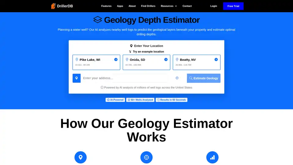
Location Input: Users enter an address, coordinates, or select from example locations like Pike Lake, WI (43.322, -88.346), Onida, SD (44.705, -100.066), or Beatty, NV (36.908, -116.759). The system pinpoints the exact coordinates and initiates a search for relevant data.
AI Analysis: The tool examines up to 50 nearby well logs within a 10-mile radius. It processes PDF documents from state databases, extracting key details such as geological formations, water levels, drilling methods, and yield data. Advanced machine learning models recognize patterns in this information, identifying correlations between nearby wells.
Prediction and Interpolation: Using pattern recognition and interpolation techniques, the AI estimates the geological conditions at the user's specific site. It cross-references predictions with available geological survey data for added accuracy, generating a layer-by-layer profile tailored to the location.
Report Generation: Within 60 seconds, users receive a customized report that includes visual diagrams, depth estimates, and recommendations. The process is powered by AI that has been trained on vast datasets, ensuring reliable outputs even in data-sparse areas, though confidence levels are provided based on well density.
This technology not only saves time but also enhances decision-making by highlighting potential challenges like caving sands or hard bedrock, drawing from real-world well performance patterns.
Key Features of the Geology Depth Estimator
What sets this tool apart is its comprehensive output, which goes beyond basic predictions to deliver practical value. The report includes:
Geological Layer Analysis: A detailed breakdown of subsurface materials, from surface soil to bedrock. It covers layer types (e.g., clay, sand, gravel, limestone, sandstone, granite), depth ranges, characteristics (color, hardness, caving potential), and water-bearing potential. A scaled visual diagram makes it easy to visualize the underground structure.
Drilling Depth Estimates: Tailored recommendations for different needs, including residential wells (5-15 GPM for household use) and high-capacity wells (50+ GPM for irrigation or commercial purposes). It also estimates static water levels and yield expectations, with confidence levels to guide reliability.
Construction Recommendations: Expert guidance on drilling methods (rotary, cable tool, air rotary), casing depths, screen placement in optimal intake zones, and grouting requirements. These are based on successful wells in similar geological settings.
Key Insights & Warnings: Highlights potential issues like drilling challenges (e.g., hard rock or caving sands), water quality concerns, cost factors, and success rates derived from nearby data. This proactive approach helps users anticipate and mitigate risks.
The tool's AI ensures these insights are location-specific, making it invaluable for site evaluations.
Who is the Geology Depth Estimator For?
This tool caters to a diverse audience involved in water well projects:
Homeowners: Ideal for those planning a new well or replacing an aging one. It provides depth estimates to help budget for drilling costs and avoid surprises like dry holes.
Developers and Property Buyers: Use it to assess water availability before purchasing land, ensuring feasibility for residential or commercial development.
Well Contractors and Drillers: Professionals can generate quick geological previews for bids, equipment selection, and service in new areas, streamlining project preparation.
By addressing the needs of both novices and experts, the estimator democratizes access to geological intelligence, empowering informed choices in well planning.
Why Choose the Geology Depth Estimator?
In the world of well drilling, where subsurface conditions can vary dramatically, having reliable predictions is crucial. Traditional methods like test borings are expensive and time-consuming, often costing thousands of dollars. The Geology Depth Estimator offers a cost-effective alternative—completely free—with results that rival professional surveys in many cases.
Users appreciate its speed and ease: no downloads, no sign-ups, just instant access via the web. The privacy-focused design ensures location data isn't stored post-session, building trust. Moreover, by analyzing patterns from millions of wells, it provides confidence levels and warnings that guide users toward safer, more efficient projects.
Real-world benefits include accurate budgeting (e.g., factoring in hard bedrock costs), selecting the right contractor, and planning for water treatment based on quality insights. For instance, identifying multiple aquifers helps optimize depth to reach the best water source, potentially increasing yield and longevity of the well.
Common challenges like clay barriers or caving sands are flagged early, reducing the risk of project failures. As one user might say, it's like having a geologist on call, 24/7, without the hefty fee.
How to Use the Geology Depth Estimator
Getting started is straightforward:
Visit the DrillerDB website and navigate to the Geology Depth Estimator section.
Input your location via address, map click, or coordinates.
Hit 'Estimate Geology' and wait up to 60 seconds for the AI to process.
Review the detailed report, complete with diagrams and recommendations.
For best results, use it in areas with available well data; if sparse, the tool notes lower confidence and suggests consulting local experts. It's optimized for U.S. locations but draws from nationwide databases.
Practical Value and Best Practices
The true power of this tool lies in its ability to save money and time. Drilling a dry well or hitting unexpected hard rock can inflate costs by 50% or more. By predicting these scenarios, users can:
Budget Accurately: Estimate depths to forecast expenses, from equipment to labor.
Select Optimal Methods: Choose drilling techniques suited to the geology, like air rotary for hard rock.
Ensure Compliance and Quality: Follow recommended casing and grouting to meet regulations and protect aquifers.
For critical projects, pair it with professional site investigations, as the disclaimer advises—these are predictions, not guarantees. Integrating it with DrillerDB's other resources, like finding local drillers or well maps, creates a full planning ecosystem.
In summary, the Geology Depth Estimator stands out as a must-have for anyone tackling water well projects. Its AI-driven precision, user-friendly interface, and free access make it an essential resource in geology estimation and well planning, helping users navigate underground uncertainties with confidence.
Best Alternative Tools to "Geology Depth Estimator"
Generate professional well as-built diagrams instantly from PDF well logs with DrillerDB's free AI-powered tool. Extracts geology, casing, and drilling data in seconds.